

Introduction to OsirisAI World Live CCTV Camera
OsirisAI World Live CCTV Camera is an online platform that allows users to explore publicly accessible CCTV cameras and global information through an interactive world map. It combines Open-Source Intelligence (OSINT) tools with different geographical and monitoring features, helping users discover camera locations and explore information from different parts of the world. The platform provides an interesting way to observe public places, roads, cities, transportation areas, and other locations through available camera sources.
Unlike traditional CCTV applications that connect to privately installed security cameras, OsirisAI focuses on publicly available information and camera feeds. Users can explore different geographical locations, select camera markers, and view supported camera streams or images. Apart from CCTV cameras, the platform also offers additional information layers related to aircraft, satellites, weather, earthquakes, and other global events.
What Is OsirisAI World Live CCTV Camera?
OsirisAI is an Open Source Intelligence platform designed to bring different publicly available information sources together in one place. Its World Live CCTV Camera feature allows users to discover publicly accessible camera feeds from different countries and geographical regions. Instead of searching for individual camera websites, users can explore available camera locations through an interactive digital map.
Related Posts
The platform is useful for people interested in global observation, geographical research, public infrastructure, and real-time information exploration. Depending on the original camera source, users may see continuous video footage, periodically updated images, or static camera snapshots. The availability and quality of camera feeds depend on the original providers and their streaming services.
How Does OsirisAI World Live CCTV Camera Work?
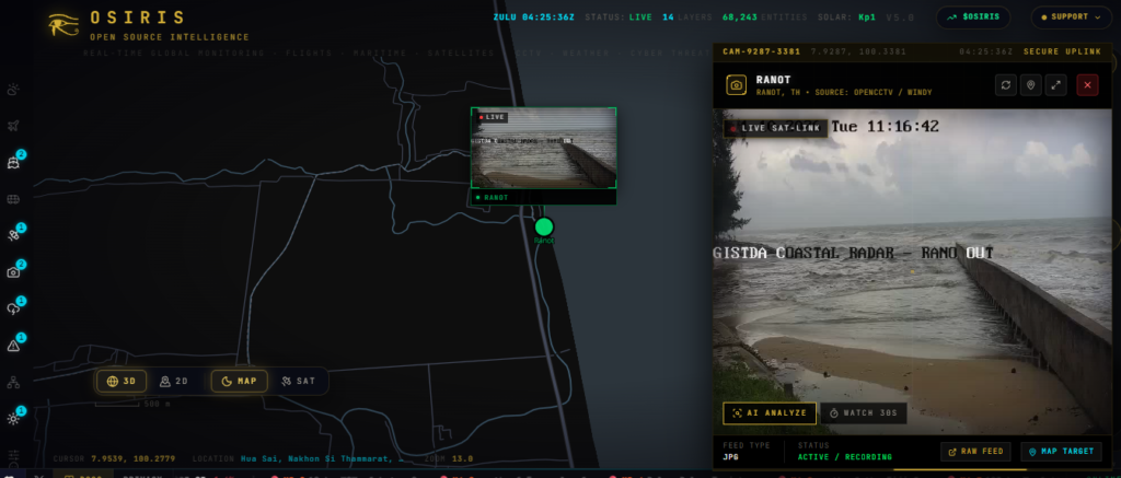
OsirisAI works by collecting and displaying information from different publicly accessible data sources. The platform uses an interactive world map to organise camera locations and other geographical information. When users open the website, they can explore different regions and activate the CCTV camera layer to identify available camera locations.
After selecting a camera marker, users can check the available camera information and access the supported viewing option. Some cameras provide live video streams, while others display regularly refreshed images. The platform also includes different monitoring layers that help users explore additional information about selected geographical locations.
The camera viewing experience depends on internet connectivity, browser compatibility, and the availability of the original camera stream. If a particular camera source becomes unavailable, users may not be able to view its footage temporarily.
Major Features of OsirisAI World Live CCTV Camera
OsirisAI offers several features that make it different from ordinary CCTV viewing websites. Its interactive map, public camera discovery, geographical information, and intelligence-related tools provide multiple ways to explore global information. Users can select different map layers according to their interests and view the available information without switching between multiple platforms.
The platform combines camera discovery with other useful monitoring features, making it suitable for people interested in technology, transportation, environmental information, and global events. Its browser-based design also makes accessing the available features convenient for different types of devices.
Worldwide Public CCTV Camera Access
One of the most interesting features of OsirisAI is its worldwide public CCTV camera discovery system. Users can explore available camera locations across different countries and geographical regions. The interactive map helps identify public cameras installed near roads, highways, city areas, transportation facilities, and other public infrastructure.
This feature can be useful for people who want to observe public locations and understand their surroundings through available camera feeds. For example, users interested in a particular city can explore its available public camera locations and check whether video footage or camera images are accessible.
However, not every camera provides continuous live footage. Some sources may offer periodically updated images, while others may become temporarily unavailable. The platform is intended for publicly accessible camera information and does not provide authorised access to private CCTV systems.
Interactive 2D and 3D World Map
The interactive world map is an important part of the OsirisAI platform. It allows users to explore different geographical regions through a visual interface rather than searching for locations manually. Users can zoom in and out, move between countries, and select different information layers to discover available data.
The 3D map experience provides an additional geographical perspective by displaying supported terrain and building information. This feature helps users understand the surrounding environment of selected locations. The combination of 2D and 3D map views makes geographical exploration more interesting and provides a convenient way to examine different areas around the world.
Live Traffic and Highway Camera Monitoring
Traffic and highway camera information can help users understand road conditions and transportation activity in different locations. Through available public camera sources, users can explore selected roads, highways, intersections, and transportation areas. This can be useful for observing traffic movement and understanding the general conditions of particular routes.
For example, users interested in a specific highway can explore available camera locations and check the displayed footage or images. Public traffic cameras may also provide information about visibility and weather conditions around roads. However, the availability of these cameras depends on the original transportation authorities and camera providers. Users should always verify important travel information through official traffic services.
Explore Different Global Monitoring Layers
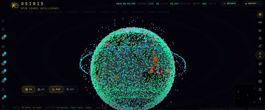
OsirisAI provides different information layers that allow users to explore multiple categories of global information through a single map interface. These layers can include public CCTV cameras, aircraft tracking, satellite information, earthquake reports, wildfire locations, weather conditions, and other geographical information.
Users can enable or disable available layers depending on what they want to explore. For instance, someone interested in a particular geographical region can examine its public camera locations along with available weather information and other monitoring data. This integrated approach makes the platform useful for understanding different types of global activity.
AI-Powered OSINT Assistant
The AI-powered OSINT assistant is another interesting feature of OsirisAI. It helps users interact with the platform using natural language instead of manually searching through every available information layer. Users can ask questions about geographical locations and available global information, making the research process more convenient.
The assistant can help users navigate relevant map information, activate suitable layers, and explore available data sources. The platform also includes AI-assisted forecasting capabilities that can analyse information and generate possible future scenarios. These outputs should be treated as analytical suggestions rather than guaranteed predictions. Access to certain AI features may require an external AI provider and an API key.
Satellite and Aircraft Tracking
OsirisAI also provides access to satellite and aircraft-related information through its global map interface. The satellite information layer allows users to explore available satellite positions and related space information. Similarly, the aircraft tracking feature helps users examine available flight-position information from public data sources.
These features can be interesting for aviation enthusiasts, technology learners, researchers, and people interested in global transportation activities. Users can explore available aircraft information and satellite positions alongside other geographical details. However, the displayed information depends on the underlying data providers, and not every aircraft or satellite-related detail may be available.
Weather, Earthquakes and Natural Disaster Information
Weather and natural disaster information are important parts of global monitoring. OsirisAI brings together different environmental information layers that help users explore weather conditions, earthquake reports, wildfire activity, and other natural events.
Users can examine available information about different geographical regions and understand where certain environmental events have been reported. For example, earthquake information can help users identify reported earthquake locations, while wildfire layers can provide geographical context about reported fire activity.
These features are useful for general awareness and research. However, the information displayed should not replace official weather forecasts, emergency notifications, or government disaster management announcements.
How to Use OsirisAI World Live CCTV Camera
Using OsirisAI is relatively simple because it is designed as a browser-based platform. Users do not need complicated installation procedures to begin exploring its available features. After opening the platform, they can access the interactive map and explore different information layers according to their interests.
To use the CCTV camera feature, users can first open the platform and allow the map to load completely. They can then locate the available Layers panel and enable the CCTV camera option. After selecting a geographical region, available camera markers may appear on the map. Clicking a camera marker allows users to examine its information and access the supported video stream or camera image when available.
The interface may look slightly different depending on the device, browser, and platform updates. Users should ensure they have a stable internet connection for a better experience.
Is OsirisAI World Live CCTV Camera Free?
OsirisAI provides browser-based access to its platform, allowing users to explore its available public information without installing traditional CCTV monitoring software. However, users should understand the difference between accessing the platform and using all its advanced capabilities.
Basic map exploration and publicly accessible information can be available through the platform, while certain advanced AI features may require an external API key. The cost of using those AI services depends on the selected provider and its pricing policy. Users should check the platform’s latest information to understand any feature-specific requirements or usage charges.
Is OsirisAI Available for Android and iPhone?
OsirisAI can be accessed through compatible web browsers on Android smartphones, iPhones, tablets, laptops, and desktop computers. Since the platform is browser-based, users do not necessarily need to install a separate application to explore its available features.
Mobile users can open the platform using their preferred browser and interact with the world map using touchscreen controls. They can zoom into geographical locations, select available camera markers, and explore supported information layers. The overall experience may vary depending on screen size, internet speed, and browser compatibility.
Privacy and Security Considerations
Privacy and security are important when using any public camera monitoring platform. OsirisAI is designed to help users explore publicly accessible information and camera sources. Users should respect privacy regulations and understand that public camera availability does not grant permission to access restricted or privately operated surveillance systems.
Users should also be careful when interacting with external camera streams and third-party services. Some camera providers may apply their own privacy policies, cookies, and data collection practices. Similarly, information entered into AI-assisted features may be processed by the selected external AI provider. Reviewing the relevant privacy and security information is recommended before using advanced features.
Benefits of Using OsirisAI World Live CCTV Camera
OsirisAI offers several advantages for people interested in global information and public camera discovery. Its biggest advantage is that it combines multiple information sources in one interactive platform. Users can explore publicly available CCTV cameras, geographical information, aircraft positions, satellite information, and environmental data without visiting numerous separate websites.
Another important benefit is its browser-based accessibility. Users can access the platform through compatible devices without installing complicated CCTV software. Its interactive map also makes exploring different geographical regions easier and more interesting. The AI-assisted features provide additional support for users who want to research locations and understand available global information.
Limitations of OsirisAI World Live CCTV Camera
Although OsirisAI provides several useful features, it also has certain limitations. The availability of public CCTV cameras depends on the original camera operators and their streaming services. Some camera links may stop working, while others may display outdated images or periodically refreshed snapshots instead of continuous video footage.
Internet connectivity and browser compatibility can also affect the viewing experience. Furthermore, aircraft tracking, satellite information, weather reports, and other global data depend on their original providers. Users should not assume that every displayed result is completely accurate or continuously updated. For important decisions, it is always better to verify information through reliable official sources.
Website Link
Conclusion
OsirisAI World Live CCTV Camera is an interesting online platform for exploring publicly accessible CCTV camera sources and global information through an interactive world map. Its combination of public camera discovery, traffic monitoring, satellite information, aircraft tracking, weather data, and AI-assisted research makes it more than an ordinary CCTV viewing website.
The platform provides a convenient way to explore different geographical regions and understand publicly available information from multiple sources. Whether users are interested in global observation, public infrastructure, transportation, or geographical research, OsirisAI offers several interesting features to explore. However, camera availability and information accuracy depend on the original data providers. Overall, it is a useful platform for people interested in Open Source Intelligence and worldwide public information.